


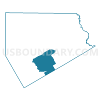
Voting District 0132, Ellis County, Texas
About
Outline

Summary
| Unique Area Identifier | 672780 |
| Name | Voting District 0132 |
| County | Ellis County |
| State | Texas |
| Area (square miles) | 71.66 |
| Land Area (square miles) | 71.10 |
| Water Area (square miles) | 0.56 |
| % of Land Area | 99.22 |
| % of Water Area | 0.78 |
| Latitude of the Internal Point | 32.22468290 |
| Longtitude of the Internal Point | -96.78880780 |
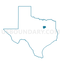
Maps

Graphs
Select a template below for downloading or customizing gragh for Voting District 0132, Ellis County, Texas


Neighbors
Neighoring Voting District (by Name) Neighboring Voting District on the Map
- Voting District 0114, Ellis County, TX
- Voting District 0119, Ellis County, TX
- Voting District 0131, Ellis County, TX
- Voting District 0133, Ellis County, TX
- Voting District 0403, Navarro County, TX
- Voting District 0404, Navarro County, TX
Top 10 Neighboring County Subdivision (by Population) Neighboring County Subdivision on the Map
- Waxahachie CCD, Ellis County, TX (77,362)
- Ennis CCD, Ellis County, TX (26,030)
- Blooming Grove CCD, Navarro County, TX (4,382)
- Italy CCD, Ellis County, TX (4,185)
Top 10 Neighboring Place (by Population) Neighboring Place on the Map
Top 10 Neighboring Unified School District (by Population) Neighboring Unified School District on the Map
- Waxahachie Independent School District, TX (41,128)
- Ennis Independent School District, TX (26,542)
- Blooming Grove Independent School District, TX (4,320)
- Italy Independent School District, TX (2,853)
- Frost Independent School District, TX (1,730)
- Avalon Independent School District, TX (817)
Top 10 Neighboring State Legislative District Lower Chamber (by Population) Neighboring State Legislative District Lower Chamber on the Map
Top 10 Neighboring State Legislative District Upper Chamber (by Population) Neighboring State Legislative District Upper Chamber on the Map
Top 10 Neighboring 111th Congressional District (by Population) Neighboring 111th Congressional District on the Map
Top 10 Neighboring Census Tract (by Population) Neighboring Census Tract on the Map
- Census Tract 611, Ellis County, TX (4,573)
- Census Tract 9704, Navarro County, TX (4,382)
- Census Tract 610, Ellis County, TX (4,185)
- Census Tract 613, Ellis County, TX (2,292)
- Census Tract 612, Ellis County, TX (2,107)
Top 10 Neighboring 5-Digit ZIP Code Tabulation Area (by Population) Neighboring 5-Digit ZIP Code Tabulation Area on the Map
- 75165, TX (37,966)
- 75119, TX (26,601)
- 76651, TX (3,300)
- 76641, TX (1,674)
- 76626, TX (1,563)
- 75101, TX (646)
- 76041, TX (434)
- 76623, TX (242)